The Tlapaneco (Méphaa) of Guerrero: Eternal Defiance
Note: The terms “Tlapaneca” and “Tlapaneco” are interchangeable and the Mexican census over the last 120 years has used both spellings. However, it is important to realize that the people known as the Tlapaneco prefer to be known by the term Méphaa. The term "Aztec" is commonly used today to describe the civilization that flourished in the Valley of Mexico during the Postclassic period. However, the people referred to by this name historically called themselves "Mexica". The name "Aztec" was later attributed to them and has become widespread in historical texts.
At its height in 1519, the Aztec Empire was a multi-ethnic, multi-lingual realm stretching more than 80,000 square miles through many parts of what is now central and southern Mexico. Fifteen million people, living in thirty-eight provinces and residing in 489 communities, paid tribute to the Emperor Moctezuma II in Tenochtitlán, the capital city of the great empire. One map version of the Aztec Empire at its height is shown below:[1]

The Independent Enclaves
For all its strength and breadth, the Aztec Empire failed to conquer several regions that represented “independent enclaves” within their vast dominion. One of those enclaves was Yopitzinco. According to Professor Michael E. Smith, in his chapter "The Strategic Provinces," in Frances F. Berdan et al., Aztec Imperial Strategies, Yopitzinco was “an isolated mountainous area along the Costa Chica of Guerrero southeast of Acapolco.” This territory was occupied by the “Yope” or “Tlapaneca,” who had a reputation as fierce warriors.[2] Yopitzinco actually comprised four Yopi states (Cacahuatépec, Pochotitlan, Xocotlan, and Xochitépec). Today, the Yopes still inhabit the southern coastal region known as Costa Chica. This area includes the coastal municipios of Azoyú and San Luis Acatlán.
The State of Guerrero in 2024
The state of Guerrero covers an area of 63,597 square kilometers, occupying 3.2% of the national territory. Politically, Guerrero is divided into eighty-one municipios. As the fourteenth largest Mexican state, Guerrero covers an area of 63,596 square kilometers, occupying 3.2% of the national territory.
With a 2010 population of 3,533,351, Guerrero has 3.0% of the total population of Mexico and is ranked twelfth among the states in total population. The capital of Guerrero is Chilpancingo de los Bravos, which had 187,251 residents in 2010. The following map provides a picture of the major cities within Guerrero in the present day.[3]
Guerrero’s Seven Regions
Guerrero is extremely mountainous and dominated by two principal mountain ranges. Environmentally, the state is divided into the following regions:
1. Tierra Caliente: The northwest interior.
2. Acapulco: The coastal area near Acapulco
3. La Montaña (The Mountain): the mountainous region in the northeast, bordering on Puebla and Oaxaca.
4. Sierra del Norte: The far north adjacent to Morelos, Estado de Mexico and Puebla.
5. Centro: The Central Valleys in the middle of the State.
6. Costa Grande: The Coastal strip northwest of Acapulco.
7. Costa Chica: The Coastal strip southeast of Acapulco.
The following map shows the locations of these regions:[4]
Between 1427 and 1519, the powerful Aztec Empire subdued neighboring city-states and compelled their new subjects to surrender part of their production as tribute. But Yopitzinco remained independent during this time as indicated in the following map:[5]
The Aztec Empire was controlled primarily by a political body known as the Triple Alliance (Texcoco, Tenochtitlán and Tlacopan). Several enclaves (marked in light gray on the map) were able to resist the Aztecs and maintain their independence from the empire:
1. Metztitlán: A powerful Otomí state in present-day northern Hidalgo.
2. The Tlaxcaltecan Confederation
3. The Popolocas of Teotitlán del Camino (Oaxaca)
4. The Tlapanecos of Yopitzinco (Guerrero)
5. The Mixtec Kingdom of Tututepec (Oaxaca)
The following map shows the location of the Yopitzinco Kingdom within the Aztec Empire.[6]
The Méphaa
The Tlapaneca called themselves Méphaa, which can be translated as “the one that is an inhabitant of Tlapa.” Tlapaneco is an Aztec designation that came from the Náhuatl word “tlauitl,” meaning “red ocher” and has a pejorative connotation: “the one that is painted (of the face),” which to the ears of the Méphaa means “to have a dirty face.” Today, the people once known as Tlapaneco self-identify only as Me’phaa.
The Méphaa have probably lived in the present-day state of Guerrero since at least 1200 A.D. They settled in two geographical areas: the areas now known as Costa Chica and La Montaña [See the Regional Map above]. They were divided into two groups:
The Méphaa of the north, seated in Tlapa
The Yopes of the south, centered in Yopitzinco
Tlapa
Tlapa in the north included an extensive territory presently located in the eastern portion of the current state of Guerrero. Known also as the Kingdom of Tlachinollan, this area was adjacent to the Oaxacan Mixteca and covered an area of over 10,000 square kilometers. The archaeologist and ethnohistorian, Gerardo Gutiérrez, described Tlapa-Tlachinollan as “a rich and powerful kingdom strategically located on the main trade route between the Pacific coast and Central Mexico. The ruler of Tlapa-Tlachinollan, Lord Rain, controlled trade between the two regions whose mountains were rich in gold and gemstones.” The Aztecs had tried “with little success” to conquer the kingdom since 1447.[7]
According to Gutiérrez, the Aztecs had recently defeated the neighboring Mixtec Kngdom of Coixlahuaca, and Lord Rain, the tlacatectli (imperial governor) of the entire region, realized that his war of attrition with the Aztecs up to that time would become more difficult as the Aztec Empire acquired more strength and developed strategic alliances. So, around 1462, Lord Rain became an ally of the Triple Alliance, negotiating a pact of cooperation with the Aztecs.[8]
However, this cooperation led to a war with a coalition of the neighboring kingdoms of Yoallan and Cuitlapan, led by nobles of prestigious families. However, Lord Rain triumphed and was able to rule for another 20+ years. Gutiérrez states that “the story of Lord Rain is a key example of pre-Hispanic native politics and diplomacy” and has been described on pictorial documents [now known as the Humboldt Codex].[9]
However, over time, due “to factional infighting and conflicts surrounding succession, Tlapa-Tlachinollan’s internal cohesion and political unity were weakened.” Lord Rain died and the Mexica initiated new military incursions into Tlapa-Tlachinollan. According to the Humboldt Codex, the Aztecs finally conquered the territory of Tlapa-Tlachinollan in 1486, leading to the death and sacrifice of many Tlapanecos.[10]
The Fall of Tlapa (1486)
The Aztecs under Emperor Illhuicamina had first moved into the region of Tlapa in 1457. But it was Emperor Ahuítzotl (who reigned 1486-1502) who conquered Tlapa in 1486. The Aztecs gave it the name Tlachinollan ("Burning Place") and it became part of the Aztec tributary province known as Tlapan. After it surrendered to the Aztecs, Tlapa was forced to pay tribute to the Aztec Empire. In contrast, the Yopes of the south were never defeated by the Aztecs and they posed a continuous problem until the arrival of the Spaniards.[11]
In their “Province Descriptions” in Aztec Imperial Strategies, Michael E. Smith and Frances F. Berdan state that “Tlapan is located in a mountainous, hot, and dry area in the eastern part of the State of Guerrero.” Over a significant period of time, Tlapan was “conquered successively by [the Aztec Emperors] Tizoc, Ahuitzotl, and Motecuhzoma [Moctezuma] Xocoyotzin.”[12]
In the following map, the borders of Tlachinollan are depicted within the green area, and some of the military campaigns launched by the Mexica Empire in the area are depicted as well, along with their dates. Even after the primary conquest of 1486 more territory was conquered by the Aztecs. The following map shows the conquest of specific regions of Tlachinollan (Tlapa) by the Aztecs over time:[13]
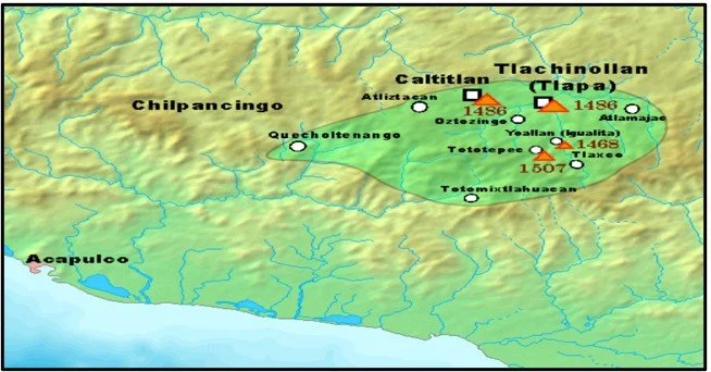
Today, the region that was once called Tlapa-Tlachinollan mainly consists of the municipios of Azoyú and San Luis Acatlán, which are part of Guerrero’s La Montaña. It is believed that the Mixtec and Tlapanec native groups that presently inhabit this area probably settled there in the 11th Century. Tlapa was the most important ceremonial center of this region.[14]
Yopitzinco
Yopitzinco (Yopitzingo) was the other vast region inhabited by the Méphaa, occupying the area south of Tlapa. Yopitzinco was located in what are now known as the Guerrero municipios of San Marcos and Tecoanapa. The Yopes were a very warlike group who would offer brave and almost continuous resistance to the Aztec armies that confronted them.[15]
The Méphaa living south of Tlapan remained independent of the Aztec Empire. According to Peter Gerhard, the Tlapanecan or Yope languages predominated along the Qmitlán River. The Aztec Empire established a fortress called Quecholtenanco, which protected the southern frontier from “the belligerent Yope.”[16] Michael Smith noted that there is evidence that the Mexica simply “lacked any desire to conquer this remote area. Nevertheless, nearby client states helped maintain the Yope frontier.”[17] The following map shows the native divisions of Guerrero as of 1519, shortly before the arrival of the Spaniards.[18] The following map shows the approximate range of Yopitzinco before the arrival of the Spaniards. Note that the region was surrounded by the Aztec Empire on all sides (except the Pacific Coast).

Map by Jonathan Rodriguez.
The Arrival of the Spaniards (1520)
The first Spaniards entered the Tlapaneca area to explore the area for gold in 1520. In 1521, Rodrigo de Castañeda took possession of the mining area of Taxco, while Gonzalo de Sandoval took control of the Chontal area, the northern mountains, the Iguala Valley, and Coixcatlalpan.[19] When the Spaniards took control, they took advantage of the structure forged by the Mexica and implemented the encomienda system. According to the existing records in the Codex of Azoyú, it is presumed that the Spanish conquest was not violent.[20] For the most part, the Spanish takeover of the Costa Grande did not meet with serious resistance after the news about the fall of Tenochtitlán (Mexico City) had arrived. This area produced cash crops such as cotton, cacao, and coconuts. During the Spanish Colonial Period, these crops would be produced on the large encomiendas and haciendas, which exploited the local indigenous population for labor.
What is an Encomendero?
In effect, the "encomendero" was a deputy charged by the crown with responsibility for the support of the indigenous people and their moral and religious welfare. Instead of being a grant of land, the encomienda was a grant of people. Typically, an encomienda included an entire village, up to several hundred men, women, and children. Their Spanish masters could force them to mine gold, cultivate crops, or carry goods like beasts of burden. It was a system that became rife with corruption and, in some cases, led to misery and death for some of the subjects [the native people]. Many of the Spanish founders were encomenderos for a period of time, a grant that recognized their services in the conquest of the region.
The Rebellion of the Yopes (1531)
In 1531, the Yopes of Cuautepec [in the Costa Chica region of Guerrero] rebelled, killing Spaniards and the Indians allied with them. The Spanish response was swift and caused the almost total extermination of the people who had to flee into the mountains. Some even fled to Nicaragua, where they were known as Subtiabas.[21] Between 1531 and 1535, the Yopes mounted three separate rebellions against the Spaniards.
Further Spanish Settlement (1533-1550)
In the 1530s, the first Catholic missionaries to enter the Tlapaneco area were the Franciscans, but they were soon rejected. In 1533, the Augustinians established a mission and convent in Chilapa. Within a two-and-a-half years, the Augustinians were able to install 22 parishes in the Tlapa area. They taught the indigenous people to cultivate cotton and indigo.
Between 1535 and 1550 Antonio de Mendoza, the Viceroy of New Spain, authorized the division of Tlapa in four parts, three of these to be delivered to three families of Spanish nobles and the remaining quarter for the Spanish Crown. In the middle of 16th century there were 6,000 tributary heads of families in Tlapa, distributed in 126 locations.[22]
The Continuing Resistance
For much of their existence during the Spanish Colonial Period (1521-1821), the Méphaa struggled to own their own land. Most of them had been stripped of their lands in the early years of the Spanish occupation, but several uprisings took place beginning in 1716. The resistance continued on all levels as many of the Méphaa suffered mistreatment on the part of their landowners.[23]
During the struggle for Mexican independence (1810-1821), the Méphaa of Atlixtac, Quechultenango, Chilapa, and Zapotitlán participated in the revolt, in an attempt to recover their lands.[24] During the Nineteenth Century, the Méphaa continued to suffer mistreatment on the part of the landowners. These led to confrontations in 1842 and the subsequent years. The peasants became even angrier as litigation for their lands did not resolve their problems. Negotiations with the government took place but failed to bring about a peace treaty. Finally, in December 1843, 25 towns of the Tlapa party made their defiance of the government clear. On October 9, 1844, about 4,000 Méphaa besieged Chilapa. And in 1849, the Méphaa revolted yet again, this time under the command of the indigenous leader Domingo Santiago.[25]
The Tlapaneco in the 1895 Census
The first national Mexican census was taken in 1895. At this time, the most common languages spoken in Guerrero were those listed in the following table.

The Tlapaneco numbered 2,140 in the State of Guerrero, representing only 2.3% of all indigenous speakers in the state. An important factor in declaring your identity as a speaker of an indigenous language is a person’s self-awareness in relation to their community. While some indigenous speakers have a great deal of pride in their spoken language, for others the declaration of speaking another tongue may be inappropriate and stigmatizing. In early Mexican censuses, this could lead to an undercount in the number of indigenous speakers.
Guerrero’s Indigenous Population in the 1921 Census
Mexico’s 1921 census asked people to categorize themselves by three primary categories: Pure Indigenous, Indigenous Mixed with White, and White. Nearly 44% of Guerrerense were identified as of pure indigenous background, and only 2.1% identified themselves as “blanca” (white). The majority of Guerrero’s population was considered to mixed heritage (54.1%), but when you combine the pure indigenous people with the mixed mestizo population, it means that 97.9% of the total population of Guerrero in 1921 was Indigenous (pure or mixed).
However, only 94,688 persons spoke an indigenous language, and this group represented 16.7% of the entire population of Guerrero, far beneath the 43.8% figure for the pure indigenous group. The two most spoken languages in Guerrero were Náhuatl and Mixteco. Tlapaneco was not listed as a specific language, but most of the 12,130 people who spoke an unspecified or other language probably spoke Tlapaneco. The following table illustrates the data revealed in the 1921 census of Guerrero.

The Tlapanecos in 2000
Unlike the Mixteco and Náhuatl languages, the language of the Tlapanecos is primarily confined to the State of Guerrero. The 90,443 Tlapaneco speakers registered in Guerrero in 2000 represented 91% of all the Tlapanecos in the entire Republic. Within the state itself, the Tlapaneco – or Méphaa – occupied about 536 communities located in 13 municipios.[26] The following map shows the 1995 distribution in the Talapaneca Region, showing three individual colors for the three divisions of the Tlapanecos: The Tlapanecos of the Mountain Area, the Coastal Area and the Central Region.[27]

Indigenous Languages in Guerrero (2010)
By percentage, Guerrero ranked number five among the Mexican states with indigenous speakers representing 15.1% of the entire population in 2010. The Náhuatl language continued to be the single largest language group. Tlapaneco was spoken by 127,244 people in the State of Guerrero, and it had a monolingual rate of 32.3%. In 2010, Guerrero had the second highest rate of monolingualism, after Chiapas. The languages spoken in Guerrero in 2010 are illustrated in the following table:

In the 2010 census, nearly one-third (32.2%) of indigenous speakers in Guerrero lived in five municipios: Tlapa, Chilapa, Acatepec, Malinaltepec and Xochistlahuaca. Of the 14 most indigenous municipios in the state, the Tlapaneco language was spoken in eight of them. The following table shows the municipios with the largest Indigenous speaking populations in 2010.

Mexico’s New Linguistic Classifications (2008)
The 2003 General Law of Linguistic Rights of Indigenous Peoples (Ley General de Derechos Lingüísticos de los Pueblos Indígenas) created the National Institute of Indigenous Languages (Instituto Nacional de Lenguas Indígenas (INALI)), a decentralized organization of the Federal Public Administration, under the Secretary of Culture, which promotes, preserves, revitalizes and researches Indigenous languages. In 2008, INALI created the “Catalogue of National Indigenous Languages: Linguistic Variants of Mexico With Their Self-Denominations and Geostatical References.” This catalogue created a new form of linguistic classification, involving linguistic variants.[28]
Variantes Lingüísticas (Linguistic Variants)
According to the Catalog of National Indigenous Languages, Mexico’s 68 language groups are broken down into 364 linguistic variants (variantes lingüísticas) in Mexico. The term linguistic variant is a neutral way of referring to linguistic differences among speakers of the same language.[29] This category is generated from two criteria: (i) a lack of mutual comprehension between users of languages that are structurally and socially distant but called by the same name; and (ii) the existence of self-denominations for each of these distanced forms of speech. Previously, the word dialect was used in this context, but this term is no longer used in Mexico.[30]
Tlapaneco is one of 18 ethno-linguistic groups that speaks a language of the Otomanguean Linguistic Family which dominates much of central and southern Mexico. There are nine variants of the Tlapaneco family as shown below:[31]
1. Tlapaneco del Sur (Southern Tlapanec) / Méphaa a tsíndíí
2. Tlapaneco del Oeste (Western Tlapaneco) / Tlapaneco
3. Tlapaneco Central Bajo (Lower Central Tlapanec) / Méphaa a xkuaixiridií
4. Tlapaneco del Suroeste (Tlapanec of the Southwest) / Méphaa a wí’i in
5. Tlapaneco del Este (Eastern Tlapanec) / Méphaa a bátháá
6. Tlapaneco del Centro (Central Tlapanec) / Méphaa a míŋuíí
7. Tlapaneco del Norte (Northern Tlapanec) / Méphaa a xirágáá
8. Tlapaneco del Noroeste Alto (Tlapanec from the Upper Northwest) / Méphaa a agua a
9. Tlapaneco del Noroeste Bajo (Lower Northwest Tlapanec) / Me’phaaxma’íín
The following map shows the distribution of the nine Tlapaneco variants as of 2020.[32]

The Méphaa’s Place in Guerrero
According to INALI and the Atlas de Los Pueblos Indígenas de Mexico, most of Guerrero’s indigenous pueblos occupy large sections of Guerrero’s mountainous eastern regions. Guerrero’s primary ethno-linguistic groups include the Nahua, Mixtec, Amuzgo and the Tlapaneco. In the following map, the Tlapaneco/ Méphaa are identified as brown.

Guerrero’s Monolingual Rate (1930-2010)
As recently as 1940, almost seven of out ten speakers of Indigenous languages in Guerrero were unable to speak Spanish. However, Guerrero’s monolingual rate has dropped considerably from 69.1% in 1930 to 31.4% in 2010. Monolingual rates among most of Mexico’s Indigenous people have dropped considerably over the decades. However, among the Mexican states, Guerrero continues to have one of the highest monolingual rates.
Many of us see monolingual speakers of Indigenous languages as representing the purest segment of the original Indigenous language and culture of Mexico. Indigenous people who do not speak Spanish seem to be largely untouched by Mexican and Spanish mainstream culture. More often than not, the communities where these monolingual people live are remote and far from the large urban centers. The rate of monolingualism in Guerrero from 1930 to 2010 is shown in the following table:

The Monolingual Rate of Selected Mexican Languages (2020)
The following table indicates the twelve most monolingual languages of Mexico in the 2020 census. There were 147,432 people who spoke the Tlapaneco language in 2020 and 29,524 of them were monolingual [i.e., did not speak Spanish]. Therefore, the Tlapaneco language was ranked with the fifth highest rate of monolingualism in the country at 20.0%.

The Tlapaneca (Méphaa) Through Time
The Tlapaneca — who prefer to be known as the Méphaa — defied the Aztec Empire for the better part of a century. Then, the Spaniards came and conquered them, but the Mépha rebelled three times against the Europeans between 1531 and 1535. They were ruthlessly subdued at that time, but never lost their identity or their spirit. The encomendero system of the Spanish conquerors was employed against them and most of them lost their land early in the colonial period. However, they never forgot that injustice and have risen in defiance of both the Spanish and Mexican governments to try and regain the rights to their land over the last three centuries.
Revindication of Méphaa Identity
After the event of the 500-year anniversary of the arrival of Europeans in America, the Méphaa began a movement of revindication of their identity and they began to stop self-identifying as Tlapaneco. Today, the Méphaa people occupy an area of 3,000 square kilometers (1,158 square miles), an area that has a rugged topography.[33] Within that area are a diversity of identities among the Méphaa, who speak nine linguistic variants and live in 14 separate regions, each with its own linguistic and cultural identity. In the 2020 census, the Mexican government agency Instituto Nacional de Estadística y Geografía (INEGI) referred to this language group as Tlapaneco. The group’s hope is that in future census data, they will be referred to as Méphaa.
Bibliography
Banco de México. Selección de Lenguas Indígenas Para la Difusión de Información de Billetes y Monedas. Dirección General de Emisión Oficina de Análisis y Estudios de Efectivo (Dec. 2021).
Comisión Nacional para el Desarrollo de los Pueblos Indígenas, “Atlas de los pueblos indígenas de México: Tlapanecos – Etnografía: Historia. Online: https://atlas.inpi.gob.mx/tlapanecos-etnografia/ [Accessed 7/14/2024].
Gerhard, Peter. A Guide to the Historical Geography of New Spain. (Revised Edition: University of Oklahoma Press, 1972).
Gutiérrez, Gerardo. The Expanding Polity: Patterns of the Territorial Expansion of the Post-Classic Señorio of Tlapatlachinollan in the Mixteca-Náhuatl-Tlapaneca Region of Guerrero. Ph.D. Thesis: Pennsylvania State University, 2002.
Gutiérrez, Gerardo. “Voices of Mexico – The Codices of Guerrero and Their Stories of Power” (2005). Online: chrome-extension://efaidnbmnnnibpcajpcglclefindmkaj/http://www.revistascisan.unam.mx/Voices/pdfs/7009.pdf [Accessed 9/2/2014].
Gutiérrez Mendoza, Gerardo and Brito Guadarrama, Baltazar, El Códice Azoyú 2: Política y T en el Señorío de Tlapa-Tlachinollan Siglos XIV-XVI. Mexico: 2014.
Instituto Nacional de Lenguas Indígenas (INALI). Catalogo de Las Lenguas Nacionales: Variantes Lingüísticas de Mexico con sus Autodenominaciones y Referencias Geoestadísticas (Jan. 14, 2008). Online: Chrome-extension://efaidnbmnnnibpcajpcglclefindmkaj/https://www.inali.gob.mx/pdf/CLIN_completo.pdf.
Matiúwàa, Hubert, “Memory of the Skin-People: The Yopes: Mbo xtá rída/Skin-People” (Translated to English by Paul M Worley and Melissa D Birkhofer) (2024). Online: https://siwarmayu.com/memory-of-the-skin-people-hubert-matiuwaa/ [Accessed 7/14/2024].
Sarmiento-Silva, Sergio (2001). Tlapanecos de Guerrero. Proyecto Perfiles Indígenas de México, Documento de Trabajo. Online:
https://www.aacademica.org/salomon.nahmad.sitton/58 [Accessed 7/24/2024].
Sistema de Información Cultural (SIC Mexico), “Pueblos Indígenas: Tlapanecos” (March 2024). Online: https://sic.cultura.gob.mx/ficha.php?table=grupo_etnico&table_id=37 [Accessed 7/14/2024].
Smith, Michael E. “The Strategic Provinces” in Frances F. Berdan et al., Aztec Imperial Strategies. Washington, D.C.: Dumbarton Oaks Research Library and Collection, 1996.
Smith, Michael E. and Berdan, Frances F. “Appendix 4: Province Descriptions” in Frances F. Berdan et al., Aztec Imperial Strategies. Washington, D.C.: Dumbarton Oaks Research Library and Collection, 1996.
Sosa, Constanza. "The Annals of the Tlapanecs.” Supplement to the Handbook of Middle American Indians 5 (1992): 42—48, 51.
Footnotes
[1] Keepcases & Sémhur, “Map of the Aztec Empire Lead by Tenochtitlán Circa 1519, Before the Arrival of the Spanish” (2010). Online: https://commons.wikimedia.org/wiki/File:Aztec_Empire_1519_map-fr.svg [Accessed 9/2/2024].
[2] Frances F. Berdan et al., Aztec Imperial Strategies (Washington, D.C.: Dumbarton Oaks Research Library and Collection, 1996), p. 141.
[3] Richard B. Franco, Map of Guerrero. Online: http://analislety.blogspot.com/2011/01/atlas-de-guerrero.html.
[4] Enciclopedia de Los Municipios y Delegaciones de México: Estado de Guerrero: Regionalización.
[5] Maunus, “Map Showing the Expansions Undertaken by Various Aztec Rulers” (August 216, 2006) at Wikipedia, “Aztec Expansion.”
[6] Giggette, “Territorial Organization of the Aztec Empire 1519” (Nov. 4, 2015) at Wikipedia Commons.
[7] Gerardo Gutiérrez, “Voices of Mexico – The Codices of Guerrero and Their Stories of Power” (2005), p. 44. Online: chrome-extension://efaidnbmnnnibpcajpcglclefindmkaj/http://www.revistascisan.unam.mx/Voices/pdfs/7009.pdf [Accessed 7/14/2014].
[8] Ibid., pp. 45-46;
[9] Ibid., pp. 44-46.
[10] Gerardo Gutiérrez Mendoza and Baltazar Brito Guadarrama, El Códice Azoyú 2: Política y T en el Señorío de Tlapa-Tlachinollan Siglos XIV-XVI. (Mexico: 2014), p. 27; Hubert Matiúwàa, “Memory of the Skin-People: The Yopes: Mbo xtá rída/Skin-People” (Translated to English by Paul M Worley and Melissa D Birkhofer) (2024). Online: https://siwarmayu.com/memory-of-the-skin-people-hubert-matiuwaa/ [Accessed 7/14/2024].
[11] Comisión Nacional para el Desarrollo de los Pueblos Indígenas, “Atlas de los pueblos indígenas de México: Tlapanecos – Etnografía: Historia.”
[12] Michael E. Smith and Frances F. Berdan, “Appendix 4: Province Descriptions” in Frances F. Berdan et al., Aztec Imperial Strategies (Washington, D.C.: Dumbarton Oaks Research Library and Collection, 1996), pp 276-277.
[13] ErickTErick, “The Borders of Tlachinollan” (16 December 2021). Derived from Vega Sosa, Constanza (1992). "The Annals of the Tlapanecs.” Supplement to the Handbook of Middle American Indians 5: 42—48, 51. Austin: University of Texas Press. Online: https://en.m.wikipedia.org/wiki/File:Territorios_de_Tlachinollan_a_principios_del_siglo_XVI.png.
[14] Comisión Nacional para el Desarrollo de los Pueblos Indígenas, “Atlas de los Pueblos Indígenas de México: Tlapanecos – Etnografía: Historia.” Online: https://atlas.inpi.gob.mx/tlapanecos-etnografia/ [Accessed 7/14/2024].
[15] Ibid.
[16] Peter Gerhard, “A Guide to the Historical Geography of New Spain” (Revised Edition: University of Oklahoma Press, 1972), p. 111.
[17] Michael E. Smith, “The Strategic Provinces” in Frances F. Berdan et al., Aztec Imperial Strategies (Washington, D.C.: Dumbarton Oaks Research Library and Collection, 1996), p 141.
[18] Áurea Commons,”Gestación y Nacimiento de un Estado: Guerrero. Investigaciones Geográficas” (2003).
[19] Peter Gerhard, op. cit., p. 111.
[20] Sistema de Información Cultural (SIC Mexico), “Pueblos Indígenas: Tlapanecos” (March 2024). Online: https://sic.cultura.gob.mx/ficha.php?table=grupo_etnico&table_id=37 [Accessed 7/14/2024].
[21] Ibid.
[22] Sergio Sarmiento-Silva, Tlapanecos de Guerrero. Proyecto Perfiles Indígenas de México. Documento de Trabajo (2001), p. 8.
[23] Sistema de Información Cultural (SIC Mexico), op. cit.
[24] Ibid.
[25] Ibid.
[26] Sergio Sarmiento-Silva, op. cit., p. 3.
[27] Ibid.
[28] Instituto Nacional de Lenguas Indígenas, Catalogo de Las Lenguas Nacionales: Variantes Lingüísticas de Mexico con sus Autodenominaciones y Referencias Geoestadísticas (Jan. 14, 2008). Online: Chrome-extension://efaidnbmnnnibpcajpcglclefindmkaj/https://www.inali.gob.mx/pdf/CLIN_completo.pdf.
[29] Instituto Nacional de Lenguas Indígenas (INALI), Lenguas Indígenas Nacionales en Riesgo de Desaparición: Variantes Lingüísticas por Grado de Riesgo (2012).
[30] Banco de México, Selección de Lenguas Indígenas Para la Difusión de Información de Billetes y Monedas (Dirección General de Emisión Oficina de Análisis y Estudios de Efectivo (Dec. 2021), pp. 7-8.
[31] Comisión Nacional para el Desarrollo de los Pueblos Indígenas. Atlas de los Pueblos indígenas de México: Tlapanecos – Etnografía (2018). Online: https://atlas.inpi.gob.mx/tlapanecos-etnografia/ [Accessed 7/14/2024].
[32] Comisión Nacional para el Desarrollo de los Pueblos Indígenas. Atlas de los Pueblos Indígenas de México: Tlapanecos – Language: Mapa de La Lengua (2020). Online: https://atlas.inpi.gob.mx/tlapanecos-lengua/ [Accessed 7/14/2024].
[33] Comisión Nacional para el Desarrollo de los Pueblos Indígenas, “Atlas de los Pueblos Indígenas de México: Tlapanecos – Etnografía: Historia.” Online: https://atlas.inpi.gob.mx/tlapanecos-etnografia/ [Accessed 7/14/2024].